InfoMaption, Inc. Project Portfolio

Mount Crested Butte Water and Sanitation District -Hydraulic Modeling and GIS Development

Mount Crested Butte Water and Sanitation District

Hydraulic Modeling and GIS Development

Mount Crested Butte, Colorado

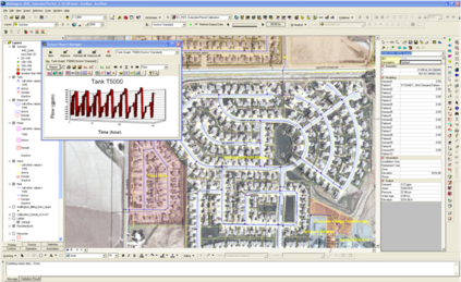
InfoMaption Inc. currently maintains the Mount Crested Butte Water and Sanitation District’s water system hydraulic model. IM aids the District with system operations, pumping requirements, and system settings, and performs evaluations for water system adequacy and ability to support developments. IM routinely updates the model with system expansion, calibration data, and system setting information and aids in guiding system improvements.

IM has also provided GIS development services for the District’s water and sewer system. IM provided field data collection services, mapping water system components for inclusion into the utilities geodatabase. As a part of this project, indexed map books were created for both water and sewer systems. In addition, IM created a web-mapping tool that allowed District personnel to access system location and asset information in the field using field tablets and smartphones, make updates to asset maintenance and condition information and to use as a work order management system.

South Cheyenne Water and Sewer District

Utilities Modeling and Master Planning

Cheyenne, Wyoming

InfoMaption Inc. was contracted with Summit Engineering to complete a water and wastewater master plan for the South Cheyenne Water and Sewer District. IM developed water and sewer system hydraulic models for evaluating system function for existing, near-, mid-, and long-term system development scenarios in order to predict system improvements and a CIP that would be required to support near and long term growth. IM was responsible for authoring the master plan document and presented to the District Board.

South Cheyenne Water and Sewer District - Utilities Modeling and Master Planning
Mill Creek Association - Rattlesnake Dam Design

Mill Creek Association

Rattlesnake Dam Design

Mill Creek, Colorado

InfoMaption, Inc. was contracted by the Mill Creek Association to provide design service for a small dam that was breached and failed during a September 2013 flooding event. IM initiated the project by surveying the existing conditions of the site and the failed portion of the dam. The design included sizing a new spillway based on updated hydrologic conditions, identifying suitable borrow material to re-establish the dam embankment, creating a new grading plan, and configuring a more suitable emergency spillway to protect the site from future flooding events. IM provided construction oversight, working closely with the contractor to ensure the dam was constructed according to the design plans. IM concluded the project by conducting an as-built survey and providing record drawings.

Sweetgrass Drainage Master Plan

Preliminary Drainage Master Plan

Cheyenne, Wyoming

Under a sub-consulting agreement with Summit Engineering, InfoMaption, Inc. provided a preliminary drainage master plan for a proposed 2,300-acre development near Cheyenne, WY. The drainage study evaluated drainage characteristics and potential impacts on the proposed conceptual layout of the development, which included residential and commercial land uses, and a proposed golf course. IM provided a preliminary hydrologic analysis in order to site regional detention facilities, stormwater conveyance alignments, and crossings. The analysis was summarized in a preliminary drainage report and presented to the County for approval.

Sweetgrass - Preliminary Drainage Master Plan
Fortune 500 Energy Company- Structures Field Verification

Fortune 500 Energy Company

Structures Field Verification

Colorado, Texas, North Dakota, Wisconsin, Minnesota, and Wyoming

InfoMaption, Inc. has worked in partnership to JF Sato & Associates on a Structures Field Verification Project for 4 years supporting a Fortune 500 energy company. IM provides change detection surveys through inspection of high-resolution aerial photography. In addition, IM is responsible for developing the mobile data collection interface, which runs on field tablets used to collect structure information, including occupancy in the field. The mobile solution integrates costume field forms that are tailored to account for specific information prompts dependent on structure type. Logical field forms ensured data integrity by requiring users in the field to select from predetermined attributes. In addition, field forms are also designed to auto-populate based on structure type dependent attributes for improved efficiency in the field. JF Sato is chiefly responsible for implementing and managing the field data collection effort to map structures near high-pressure natural gas transmission pipelines. IM is responsible for integrating field data back into the master structures geodatabase, QA/QC, and submittal to energy company as a part of their risk management program.

South Cheyenne Water and Sewer District

Inflow and Infiltration Study

Cheyenne, Wyoming

In partnership with Summit Engineering, InfoMaption Inc. was contracted to perform an inflow and infiltration (I&I) sewer study in order to quantify and locate problem areas plagued by I&I (illicit storm and groundwater getting into the sewer system). IM installed precipitation gauges used to quantify rainfall events that contribute to the inflow portion of I&I. In conjunction with sewer flow meters collecting flow data throughout the system, spikes in flow due to rainfall events were quantified to identify problem areas. The infiltration portion of I&I was assessed by comparing sewer flows for both wet and dry times of the year. IM also integrated sewer video monitoring reports into the District’s sewer GIS, accounting sewer line defects to further prioritize a replacement program. Ultimately, a capital improvement plan was prepared to help guide the District for structuring a sewer line replacement program and a proactive approach for limiting I&I within the District.

South Cheyenne Water and Sewer District - Inflow and Infiltration Study
The Town of Windsor - Traffic Sign Mapping

Town of Windsor

Traffic Sign Mapping

Windsor, Colorado

InfoMaption, Inc. was contracted by the Town of Windsor, Colorado, to perform an inventory of all town-maintained traffic signs. The project consisted of mapping and attributing all street signs utilizing CarteGraph asset management software. IM aided in the development of geodatabase and custom field forms used for the data collection effort and integration into the town’s enterprise GIS system. As a part of the project, retro-reflectivity measurements for each sign were captured and integrated into the database in order to validate sign reflectivity requirements of the Federal Highway Administration.

Select Energy Services

Oil and Gas Well Mapping

Colorado and Wyoming

InfoMaption, Inc. in conjunction with Dahlgren Consulting, was contracted to develop maps displaying oil and gas permits and permit application locations for use in business planning and additional resource facilities. The GIS spatial data for the oil and gas well locations were obtained from the COGCC and WOGCC sites and was formatted to display well permits and E&P company information for strategic business planning.

Select Energy Services - Oil and Gas Well Mapping
Clean Harbors - Client Site Mapping

Clean Harbors

Client Site Mapping

North America (U.S. and Canada)

InfoMaption, Inc. was contracted by Clean Harbors to construct an interactive Google Earth mapping system. This mapping system was used to display client site locations and associated project managers, as well as historical and projected revenues. The interactive map was utilized for the company’s strategic planning efforts.

READY TO GET STARTED?